AERIAL PHOTOGRAPHY ENDERBY LAND ANTARCTICA 1975/76
PREPARATIONS
A high altitude familiarisation course held by the RAAF at Point Cook on 25 November 1975 was attended by four National mapping personnel namely Messrs Ertok, Greenall, McMaster and Morgan. Included in the activities was a decompression chamber test in which conditions at 24,000 feet were simulated and participants observed their own and others symptoms when the oxygen supply was withheld for several minutes.
On 27 November 1975 a camera test flight was made in the Pilatus Porter VH-FZB to 20,000 feet. From the results of the photographs a further half inch was cut away from the fuselage to obtain an unobstructed field of view for the Wild RC9 aerial camera.
Flight lines were drawn up for a 30% side overlap at 14,000 feet terrain clearance running north/south and parallel to the 53°E meridian.
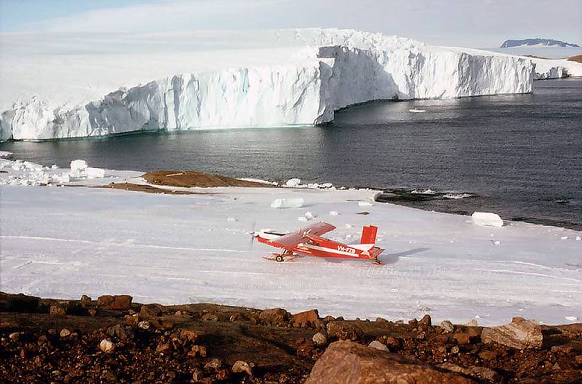
Swiss Pilatus Turbo Porter fixed wing aircraft VH-FZB provided by Forrestair, a division of HC Sleigh Limited, on the Mawson airstrip in 1975 (courtesy Ozcan Ertok).
OPERATIONS
The MV Nella Dan departed No.13 North Wharf at 2300 on 8 December 1975. It moored alongside the fast ice 65 kilometres north-west Mawson on the evening of 25 December. The Porter was lowered onto the fast ice at 2300 and assembled. It carried out a test flight at 0530 on 26 December and then flew into West Bay, Mawson.
The Porter was made available for photography on the evening of 6 Jan 1976 when it arrived at Mount King, with Mr Ertok and the camera gear. Prior to this time, it had been engaged in ferrying gear from Mawson to Mount King.
During the test flight on 7 January 1976 the film transport system jammed and blew a fuse. This was later found to be caused by a faulty spool.
A further test flight on 8 January 1976 revealed the failure of the fiducial mark and information globes, due to a loose connection at the system micro switch.
Photography commenced on 9 January 1976. Only two of the next 30 days were ideal for photography on all of the day and ten days were suitable for photography for part of the day. The camera and ancillary equipment were removed from the aircraft on 7 February 1976 at Mount King and flown to Mawson the following day.
Navigation was by ERTS (later named LANDSAT-1) satellite imagery at a scale of 1:250,000 with blue ice areas as well as rock features visible on both the ERTS and the ground. After the first day the gyro in the B3 drift sight S/N AP-41-6824 didn't work so it was replaced with the spare one at the first opportunity which didn't arise until 26 January 1976. The gyro in the second B3 sight S/N AC-4l-2601 functioned normally but with both units the window glass, at the base of the tube protruding from the aircraft would fog up from condensation from the inside freezing.
This freezing would occur on the ground and during ascent and the glass had to be taken out and wiped clean during flight. Gaps in the photography are envisaged particularly over the featureless areas such as the dome east of Sheelaghi Island as the drift sight was fogged over and distant rock features or icebergs weren't visible.
The radar altimeter developed an intermittent fault which was solved by changing the matching between the indicator and transceiver units. Radar altimeter readings were made at each exposure and have been recorded in Field Books 16365 and 16369. Over the fast ice, the readings ranged from 19,250 to 20,000 feet with the aircraft pressure altimeter set on the local QNH and reading 20,000 feet. The indicated pressure altitude readings during runs did not vary by more than ±50 feet of 20,000 feet. The lowest terrain clearance read was 12,700 feet on the run from Knuckey Peaks to Sandercock.
The Wild RC9 camera Serial No.616 was used exclusively and was fitted with an antivignetting filter. The shutter speed was constant at 1/800 of a second and the aperture setting while mostly F/11 was opened to F/8 on some occasions and f/5.6 on one occasion. A black and white test film was taken and developed every three or four flights. The aircraft skis were pumped up to move them out of the field of view. No oil leaked from the hydraulic undercarriage system and spilt onto the drift sight, as had been encountered in previous years. The forward overlap was 80 percent for all runs. Twelve rolls of Kodak Aerocolor Negative Film 2445 were used and film numbers CAS/C/8650 — CAS/C/8661 have been allotted.
As control points were established by the traversing party, proposed tie runs were altered to pass over the control. For the Nye Mountains, the southern tie run was flown first and Krasin Nunatak chosen later on as a suitable JMR point. Tie runs were generally flown when the sun angle was lowest.
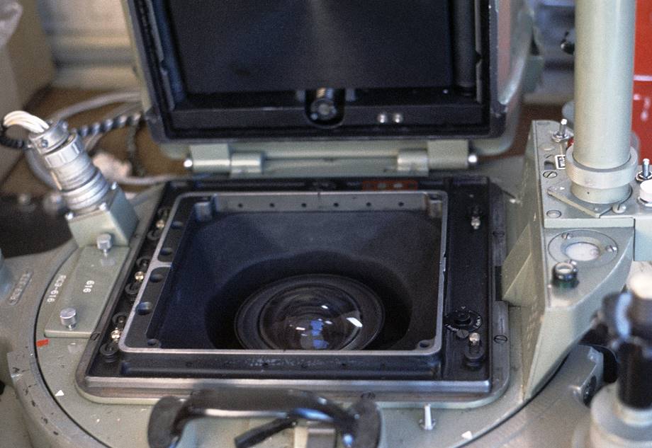
Wild RC9-616 aerial survey camera with film transport system hinged open to show the lens and focal plane with the fiducial mark and information apertures in the corners and along the left hand edge (courtesy Bob Goldsworthy collection).
COVERAGE
The area between longitudes 48°E and 51°30'E was designated first priority due to its high concentration of rock features. Ninety five percent of this area was covered before other lines were flown. An attempt was made to keep the area covered at any one time in a block with tie runs flown to complete that section. Although not originally planned, Kiri Nunataks were photographed on a day when cloud prevented photography in all but this area. The original proposed flight lines in the Molodezhnaya area were shifted by allowing for the greater terrain clearance towards sea level which would have made it possible to complete these outstanding lines in two sorties on the one day refuelling from the temporary fuel dump north of Mount Douglas. Three full drums remain at this depot on blue ice and should be available for the Porter's use next season. In any case it is suggested that at the earliest state of the planning meetings the subject of fuel requirements at Molodezhnaya be raised. The total length of coverage was 6000 line kilometres and together with the 2 runs from 1974/75 approximately 45,000 square kilometres have been photographed in Enderby Land.
WEATHER
Cloud interfered with the programme on all but two days. Some runs were flown through thin layers of medium cloud (base 14,000 feet), cutting out some of the detail although when directly above, ice features were quite distinct through the drift sight and camera telescope. Cumulus built up during the day over the mountains in the vicinity of Mount King. On the Mount Codrington 1:250,000 scale map sheet Run 15 was reflown for the section over Mount Cordwell and Mount Jewell due to excessive cloud. Run 10 from McDonald Ridge north to the coast will have to be reflown due to cloud. Coastal cumulus was often present above the ice free areas of the coast and will be visible on many of the coastal runs.
Where possible, flying during the middle of the day over featureless country was avoided. In order to photograph the ice features when the sun was low, the hours of flying were extended to range from 0540 - 2200 LMT. Two flights were made on all days that weather permitted.
Terminal weather at Mount King prevented flying on some occasions when other areas were clear for photography. Ground wind speeds in excess of 30 knots created enough drift to prevent flying. The uncertainty of the terminal conditions with the possibility of poor weather moving in quickly, was often the reason for not taking off. In these cases, if a secondary base was available the aircraft could be more fully utilized.
Winds at 20,000 feet usually had a southerly component with an average drift being 10°. The largest drift experienced was 23°Port. Some NE winds were encountered approaching the coast.
AIRCRAFT VH-FZB
Availability : The aircraft was available exclusively for aerial photography for the period 7 January 1976 - 3 February 1976 inclusive, during which time one flight was made to Mawson. No flying was possible from 4 February - 7 February 1976 and the decision to evacuate Mount King was made in this period. The only aircraft unserviceability occurred on 31 January 1976 when the fuel filter warning light illuminated and the aircraft returned to base on completion of the run. Due to the restricted number of hours flown, the pilot did not have to stand down at any stage because of excess hours.
Performance : The Porter had no problems in reaching an altitude of 20,000 feet as had been experienced last year with the aircraft VH-FSB which was destroyed in a blizzard. The time to altitude from Mount King (elevation 3,500 feet) was as fast as 32 minutes with full fuel, but considerably longer with extra weight of an additional person. Fuel consumption was 24 gallons per hour during climb and 22 gallons per hour at operating altitude. The longest sortie was 5 hours 20 minutes and on this flight 650 line kilometres were photographed.
Oxygen : No real problems were encountered with the pressure demand oxygen system. It is difficult to estimate accurately the consumption rate due to several variables but at worst 1 cylinder of 3600 psi should be allowed for 25 hours of flying including climbing and descent time. If filled to its capacity of 1800 psi there is enough oxygen in the aircraft system to allow the two man crew plus pilot to operate for the duration of two full sorties before replenishment of oxygen is required.
Communications : The aircraft intercommunication system functioned satisfactorily.
Airstrip : The airstrip was constructed by the wintering party and is likely to be used again in 1976/77. It measured 120 feet by 1100 feet bearing 095 decrees. Drums were laid out at a constant interval along the edges of the strip with the start of the runway marked on either side with 2 drums welded together, upright and blackened to stand out in ground drift and partial white out.
Snow Wall : A snow wall was bulldozed to protect the aircraft from damage in high winds. The wall succeeded in creating a drift generating bucket with drift penetrating inside the cabin on occasions despite the sealing tape, thus the time taken to clean up after a blow, was increased substantially. Winds in excess of 50 knots were not encountered.
ADDITIONAL PROJECTS
Mawson Station Photography : Black and white vertical aerial photography using a hand held Hasselblad 70mm camera was flown at four levels from the Porter over the Mawson station area.
Frames Mountains Photography : The opportunity did not arise to photograph the 13 runs needed to adequately cover the Frames Mountains area required for the compilation of a new 1:100,000 scale map.
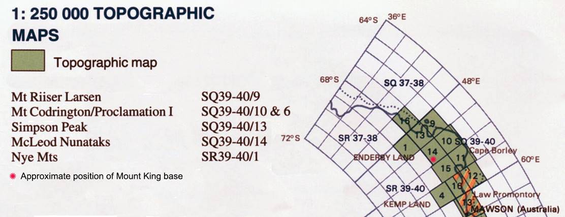
Map showing the approximate position of the Mount King base in relation to Mawson and the map areas where the 1975/76 aerial photography was achieved.
CONCLUSION
Although committed to the Porter for photography next year it is recommended that a more suitable aircraft be used for future operations. The payload of the Porter is incredibly low for a logistic support aircraft, considering that over 12,000lbs had to be flown from Mawson to Mount King before photography could begin and this involved 41 valuable flying hours for the Porter alone. There is limited space inside for photographic operations with three magazines, full survival gear and a pump for refuelling. For a more stable flying platform and greater accuracy in navigation, an automatic pilot should be installed with a remote control for the navigator's use during the run.
The Porter flew for 148 hours this summer, 74 of which it was engaged on photography. Of the remaining hours, 10 were for ice reconnaissance flights, 5 for ship to shore ferrying and 59 for Mawson to Mount King flights. Block coverage was obtained for the 1:250,000 scale map sheets for Mount Riiser Larsen, Simpson Peak, Mount Codrington and Proclamation Island while all rock features were photographed for the Nye Mountains, Sandercock Nunataks and McLeod Nunataks sheets.
|
|
|
14.4.76 |